about cvv | task forces | projects | press | publications | donate | gift shop| capay valley region | contact us | sitemap | home
email : info@capayvalleyvision.org telephone : (530) 723-4054 address : PO Box 799, Esparto, CA 95627
Natural Resources of the Capay Valley Region
Water and Soils of the Capay Valley Region
Cache Creek
Since the 1850s Cache Creek has served as one of the state's oldest gravity-based water supply channels, bringing water from Clear Lake and its tributaries to Yolo County. Today the Yolo County Flood Control and Water Conservation District manages the water resources ro provide irrigation water to tens of thousands of acres throughout western Yolo County.
The stream is one of the last primarily natural channels in California. Dams on upstream tributaries have impounded water for flood control and summer supply purposes, but proposals to build other water storage facilities in the canyon and valley have not gone forward because of various engineering or political factors.
During the irrigation season water is released into Cache Creek from two upstream reservoirs, Clear Lake and Indian Valley Reservoir, for transport to Capay, where it is diverted into the canals of the Yolo County Flood Control & Water Conservation District. Because of the complicated relationship between natural flow and released water, the riparian rights of landowners contiguous with the creek are limited and subject to the jurisdiction of the District. The District's inflatable rubber dam above Capay serves as the diversion point for releasing water from the creek into two main channels-Winters Canal to the south and West Adams Canal to the north. This water irrigates more than 50,000 acres downstream while also recharging the aquifer.
Besides providing irrigation water, spring and summer releases from the upstream reservoirs make Cache Creek, naturally an ephemeral stream, into a year-round stream that offers recreational opportunities for thousands of rafters, kayakers, and swimmers.
In wet winters creek bank erosion is common, and flood years can be very destructive. Tamarisk invasion in the stream channel has also increased the problem, causing "rebound" erosion and crowding out native vegetation.
The waters of Cache Creek are naturally high in Boron, resulting in Boron accumulations in the soil and groundwater that can be toxic to sensitive plants and crops. Bear Creek, a tributary, is a primary source. Boron levels in the creek fluctuate during the year and are at their lowest point during summer releases and winter flood events because of the dilution factor.
Cache Creek is also impaired by Mercury, originating largely from abandoned mines in the upper watershed. The creek is a major contributor to the Mercury problem in the Delta and San Francisco Bay.
Soil Types and Uses
Over the centuries Cache Creek has deposited both Capay Valley and downstream soils, which are as diverse as the topography. The historic uses of these soils have also been diverse and continue to be explored.
Two complementary systems exist for classifying soils: capability classes, wherein soil types are grouped into seven classes from I to VII, based on increasing limitations of use, and the Storie Index, wherein soil types are classified from 0 to 100, based on decreasing limitations. Prime soils are versatile, with few limitations, and are usually defined as Class I and II or soils with a Storie Index greater than 80.
From an agricultural viewpoint, the soils of the valley floor range from excellent to poor. The best soils, such as the Yolo, Brentwood, and Zamora series, are formed from recent creek deposits and usually lie in varying widths along the stream margins. These soils are suitable for all crops, including orchards, and provide the fewest challenges to farm management.
Soils of intermediate quality, such as the Marvin and Capay series, are suitable for the cultivation of annual crops but require close management because of their inherent limitations.
Poorer soils, such as the Hilgate and Corning series, occupy the low terraces. Because of heavy clay subsoil, their use is severely restricted, and these soils are generally not suitable for cultivation.
Mountainside soils can be characterized as shallow, fragile, and subject to erosion. Use is limited to habitat and grazing.
Because excellent soils can adjoin poor soils in the same field, professional soil evaluation is recommended for those contemplating farming endeavors. For soil maps and a full discussion, consult the Soil Survey of Yolo County, available at the Natural Resources Conservation Service or Agricultural Cooperative Extension Service offices in Woodland.
Historical Precipitation and Climate Records
Esparto-Capay Valley Region
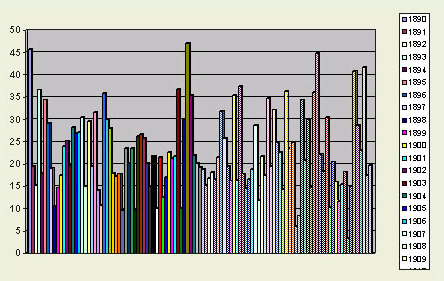
Historical Rainfall Totals, 1890-2000, at Capay
(California Department of Water Resources)
Precipitation patterns are characterized by wide variability from year to year.
Average rainfall 22.88 -- Maximum 47.05 (1941) -- Minimum 3.4 (1993)
Number of years 40 inches or more: 5 Number of years 15 inches or less: 19
Number of years 30 inches or more: 25 Number of years 10 inches or less: 7
Flood events as measured at Cache Creek near Capay since 1950
February 1958; December 1964; January 1965; January 1970 [station discontinued]
Flood events as measured at Cache Creek at/above Rumsey
January 1965; January 1970; January 1983; January and March 1995; January 1998
Historic drought periods
(2 successive years of less than 15 inches, or several years of substandard precipitation)
1898-1899
1912-1913
1917-1920
1933-1934
1947-1950
1959-1962
1976-1977
1989-1994
Cache Creek Basin Climatic Data, Brooks (el 294 ft) (California Department of Water Resources) The climate of the Capay Valley (Cache Creek Basin), like most of Northern California, is characterized by cool wet winters and hot dry summers. Temperatures range from slightly below freezing in most winters to highs of more than 100 degrees Fahrenheit during the summer. Hard freezes occur relatively rarely but can damage sensitive plants and trees. Similarly, occasional heat waves occur, especially in July and August. The following data from the California Department of Water Resources show average readings for temperature and precipitation over several decades.
Years of Record45 years 51 years
MonthAv Temp F Av Precip In
Jan44.8 4.06
Feb48.54.10
Mar52.92.63
Apr58.21.31
May65.30.60
June72.40.20
July78.40.01
Aug75.80.02
Sep72.10.19
Oct63.40.96
Nov52.61.75
Dec46.04.17
Recreational Uses of Natural Lands
The natural values of the Capay Valley region have always attracted visitors interested in scenic drives, natural history, and recreation. As California grows increasingly urbanized, these values becomes even more significant because of their increasing scarcity.
The rugged slopes of the Blue Ridge, the oak-studded foothills, the riparian vistas, and human-scale agriculture are all part of the scenic attraction of the valley. During the annual Almond Festival in February, many visitors take the opportunity to enjoy early spring weather by driving the length of the valley and participating in various low-key community activities.
Birdwatchers like the valley because of the number of resident and seasonal species that can be found throughout the area. Bald eagle nesting sites have become established within the canyon, and other raptors frequently hunt prey along the creek. Wild turkeys are increasing in numbers, and valley quail are common.
Hikers from throughout Northern California are attracted to the country roads and the growing number of trails maintained by the Bureau of Land Management in the canyon area. Rafting and kayaking on the Class I-III rapids of Cache Creek have become increasingly popular summertime activities, drawing many visitors from the Bay Area. Two commercial rafting companies offer overnight rafting trips as well as day rentals from Memorial Day weekend through Labor Day.
Yolo County maintains three county park sites in Cache Creek Regional Park, two for day use and one for overnight camping. Another county park is situated along the creek just south of Guinda along Road 57. This park, nearly decimated by the floods of 1998, is being redeveloped and attracts a number of local visitors, particularly on weekends.
Regional Vegetation and Wildlife
The native vegetation of the Esparto-Capay Valley region consists largely of oak woodlands, grasslands, and mixed chaparral, depending on elevation and topography. Cache Creek and its tributaries support native riparian communities of many species, including wetland grasses, rushes and sedges. While more than a century of settlement and agricultural development has altered the original landscape, the valley and its surrounding hills and low mountains continue to offer rich habitat for wildlife and numerous opportunities for outdoor recreation, including bird-watching, hiking, rafting, horseback riding, hunting and fishing.
Indigenous Plant Species (partial listing)
Alder
Black walnut
Blue oak
Buttonbush
Calif. buckeye
Calif. sycamore
Ceanothus
Coffeeberry
Cottonwood
Coyote bush
Elderberry
Gray pine
Hollyleaf cherry
Manzanita
Madrone
Mulefat
Ribes
Rhamnus
Toyon
Valley oak
Western redbud
Willows
Indigenous Wildlife Species (partial listing )
Mammals
Badgers
Bats
Beavers
Black bear *
Bobcats
Coyotes
Deer
Feral pigs
Gray foxes
Mountain lions
Opossums
Rabbits
Raccoons
River otters
Skunks
Tule elk *
(* BLM lands)
Birds
Bald eagles
Blackbirds, orioles
Bluebirds
California quail
Chickadees
Crows, ravens
Doves
Ducks, geese
Finches
Hawks, osprey
Herons, egrets
Hummingbirds
Jays
Kingbirds
Magpies
Mockingbirds
Owls
Phoebes
Robins
Sparrows, towhees
Starlings, vireos
Swallows
Swifts
Titmouses
Turkey vultures
Warblers
Wild turkeys
Woodpeckers
Wrens
Wrentits
Fish
Catfish
Carp